Martins Lookout to Lost World Lookout
Martins Lookout to Lost World Lookout
If you’re keen for a solid workout while taking in gorgeous valley views and stunning sandstone overhangs, then look no more. This hike is challenging but offers fantastic scenery, a bit of history, and an unforgettable experience! Ready to take on your next adventure?
Quick Details
Length: about 9km return
Elevation: 220m
Grade: Hard
Best season: Autumn, Winter, Spring
Suitable for kids: Young kids no, teens would be fine if they’re ok with the steep elevations
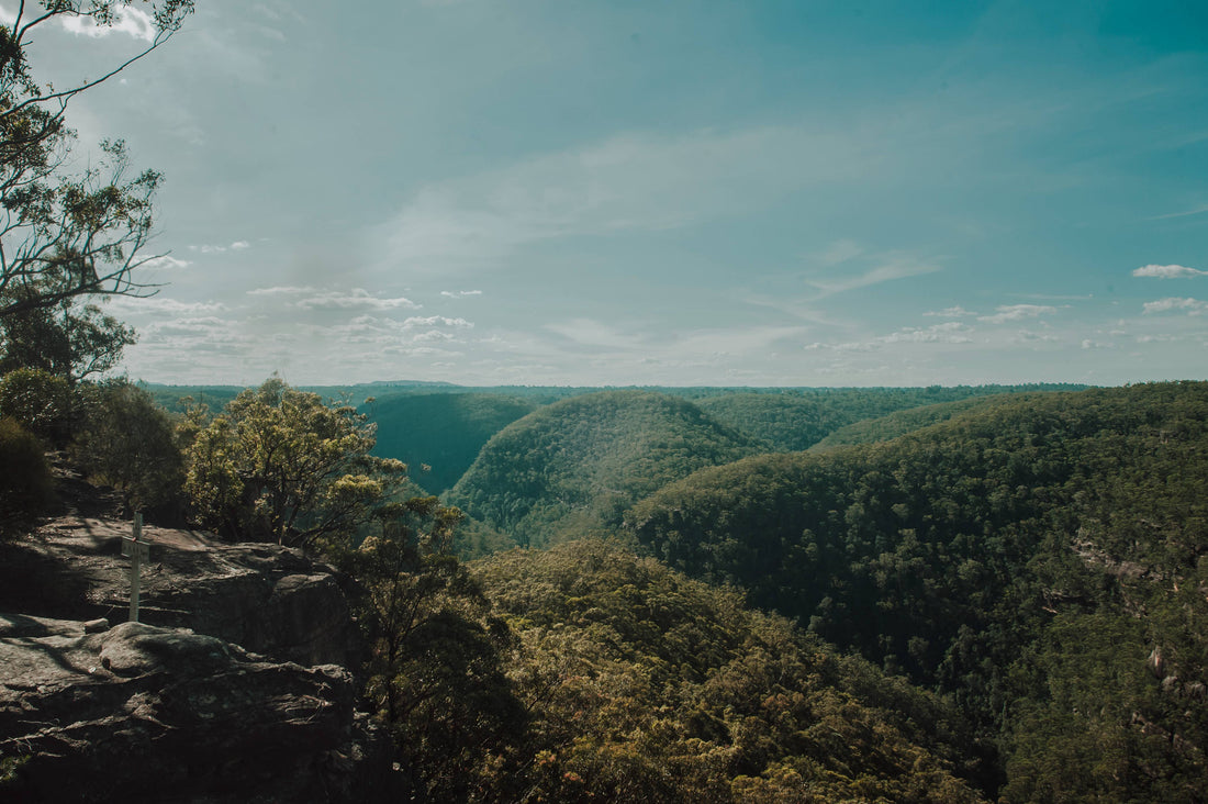
Martins Lookout
From the car park you’ll walk only a short 100m or so to Martins Lookout, you'll immediately be greeted by spectacular views across Glenbrook Creek. You’ll find a small metal plaque on the ground directing you to spot the tiny white cross in the distance on top of the sandstone across the valley - your destination at Lost World Lookout. The cross commemorates Reverend Raymer, a local bushwalker who explored these trails extensively.

The trail heads down the hill to your left, leading you down a stone staircase into the bush. The trail descends through the valley by switchbacks. As you get lower the dry Aussie bush gives way to greener plant life and past a few sandstone overhangs. The way down is steep, but manageable.

Glenbrook Creek
As you reach the creek you’ll come to a junction in the track. Turning to the right will take you upstream of Glenbrook Creek towards Perch Ponds, and the Magdala Falls track. Here we turned to the left on the Kings Link track. From here there’s less maintained track and it’s recommended to have route finding experience.

We walk down to the creek and decide to take a quick dip before continuing on the trail. The day is hot and the water looks too inviting! We find a pool deep enough for us to swim in not far from the track.

After heading back to the trail we cross the creek and find a red ribbon marker tied to a tree to mark where the trail starts on the other side. Here it turns to the left and we head down stream a short way before reaching another junction.

Psalm Rock
We take the track to the left for a quick detour to Psalm Rock. We had seen it on the map and were curious as to what it was. A short way downstream we see a small overhang on the left side of the creek with an old piece of graffiti on it and presumed this must be Psalm Rock. It wasn’t until we finished the hike and looked up Psalm Rock online that we realised we had the wrong place.

A little further downstream is the actual Psalm Rock - named for the engraving of Psalm 23 carved into the rock face. For those of us who haven’t been to Sunday School in a while, Psalm 23 is the one you often hear recited at funerals - “...Though I walk through the valley of the shadow of death…”
There doesn’t seem to be an answer to when it was carved or why. Our guess is that perhaps a stonemason apprentice was looking to practice their craft. The lettering looks quite neat from the photo’s we’ve seen online. There’s so many sandstone overhangs on this trail carved by mother-nature, and they’re all so beautiful.

Back to the Trail
We head back to the junction, and this time take the track on the right - heading up the hill. More switchbacks and old stone stairs lead us up out of the valley. The trail is steep and in the hot weather it’s tough going! We reached a sandstone lookout and here we needed to do some rock scrambling to get up to the top. It wasn’t easy - even my long legs were struggling with the task.

We take a moment to appreciate the view. We’re only a third of the way up the hill at this point but the view, even though a little obstructed by trees, is beautiful. The trail continues up the hill slightly to our right. Here it starts to get a little obstructed and is difficult to see in some places. A second rocky section is easily passed by a staircase through the rock.

Bunyan Lookout
As we finally reach the top of the hill we turn to the left to walk out to Bunyan Lookout. We pass a small fire pit in a clearing. It looks like a great place to camp and would offer fantastic views for the sunrise. There’s no water source nearby however, so if you were to camp here be sure to bring plenty of water.

From here the trail is mostly flat, winding through the bush. This stretch is a pleasant walk through open forest, allowing us both to recover and appreciate the beauty of the lower Blue Mountains. We reach another junction in the trail with a marker pointing us in the direction of Lost World Lookout.

The trail continues through the bush, high scrub both sides of the track makes it feel like walking through a scratchy corridor. Beautiful Banksias are starting to bloom, and Broadleaf Drumsticks line the trail. This would be a beautiful section of the hike when they were all out in bloom.

We reach one last fork in the trail and turn to the right. From here it’s only a short stroll to the Lost World Lookout.

Lost World Lookout
The scrub clears away, offering another possible camp site, and easy access to the sandstone ledges and the incredible views beyond. It’s hard to pick out Martins Lookout from here but you can take in the views of the entire valley and it’s really beautiful. On clear days you can even see Sydney in the distance.

We find the memorial cross for Reverend Raymer. It’s not uncommon to find memorials on hiking trails. Although I think this is the first time we’ve come across one quite like this, with the plaque on one side of the valley and the cross on the other. The weathered sandstone beneath us on this side looks as beautiful as the many sandstone overhangs we’ve already passed by today, but there doesn’t seem to be a way down there to take a closer look.

From here you would turn around and return the way you came. We continued on to Sharks Head Cave - A sandstone overhang about half way down the hill to the left. That section of the trail we found difficult and wouldn’t recommend it to anyone unless they were experienced in navigation. We’ll show photos of Sharks Head in an adjoining hike in another story.
Getting There
Martins Lookout can be found at the end of the Martins Lookout Trail in Springwood in the lower Blue Mountains - around an hour from Sydney. Turn onto the trail from Farm Road. It's a single lane sealed road. You can drive all the way to the end to find a small car park.
Tips and Tricks
Avoid hiking this trail on a hot day. Even though there’s shade we found the heat added to the difficulty of the trail as the elevation gains are steep.
Have an offline map of the area as the track disappears in some places between the creek and Lost World lookout.
Bunyan Lookout and Lost World Lookout would both offer fantastic views of the sunrise.