Mount Solitary by Kedumba Pass
Mount Solitary by Kedumba Pass
Tough, remote, and utterly breathtaking — this isn’t a hike you stumble into by accident. Mount Solitary via Kedumba Pass is a serious adventure through Blue Mountains wilderness, where the views are wide, the climbs are steep, and the sense of solitude is absolute. While it’s usually done as a multi-day hike, we decided to take on the challenge of the full hike — out and back — in a single day. This is Mount Solitary via the Kedumba Pass.
Quick details
Length: 34km
Elevation: 1409m (total elevation gains across the full hike)
Grade: Hard
Best season: Autumn, Winter, and Spring
Suitable for kids: Young kids no, tweens and teens yes if they’re ok with the distance.
Before Heading Out
Rob had invited us to join him and a few friends on the hike. Jess couldn’t make it, but I decided to go anyway — then pulled out — then changed my mind again. I was intimidated by the length and elevation gain, and worried I wouldn’t keep up. It’s been months since I’ve done a long hike. But one of the guys was bringing his 12-year-old son along, and I’ll be damned if I’m going to be out-hiked by a 12-year-old… A girl has her pride.

6.45am — I’ve just finished my coffee, and I’m seriously questioning if I need a new hobby
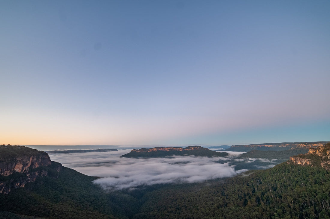
It’s not often I’m up at 5:30am and ready to hit the trail this early. But with such a long day ahead, an early start is essential. Even still, I'd prefer to be back in bed asleep. I pulled up at the locked gate on Kedumba Valley Road in Wentworth Falls — last to arrive. Everyone else was already standing just off the road, looking out at the cloud-filled valley below.

On a clear day you can see the whole valley from here, but the clouds on our visit were so low they blanketed everything beneath the cliffs. Mount Solitary peeked out above the cloud cover in the distance. We did, however, have a great view of the curving cliff line we were standing on. Obligatory group photo (thanks Grahame from Ask Roz), and then we were off.

The first section of our hike is a fire trail carved out by the Cleary family in the 1950’s, after they purchased land in the valley from the Maxwell family. Before that, a treacherous track known as the Goat Track (or the Bushrangers Track), which followed a foot track previously used by the Gundungurra people, was the main route in and out of the valley. A monument to Dan Cleary and his son can be found along the trail around 1.8km from the gate.
![]()
7.30am and the clouds haven’t cleared
As we round a bend and face the valley once more the track becomes a lot steeper and changes to concrete. We stop at a couple of spots to look out into the valley. The clouds aren’t clearing yet but the distant view of the fog rolling through the Eucalypts below is really pretty.

We continue on the trail and walk under a man-made overhang — the forest around us growing thicker as we descend further into the valley. We pass through a few closed gates, and by the turn-off for the Sublime Point Trail — apparently a shorter, but rougher, way in. We stuck to the easier option (coffee’s wearing off, no need to make life harder).

The track continues to wind down the mountain side through the foggy trees. We can hear lyrebirds calling out, and we were lucky enough to see one fly up into a tree over the track. The fire trail section of the hike is long but we can make good time as it’s all downhill — at least for now.

9.00am Cleary’s Clearing and the Slab Hut
The dense forest gives way to the open space of Cleary’s Clearing. It’s large enough to be seen from on top of the sandstone walls around the valley. We take a short detour to check out the old Maxwell Slab Hut — originally built by William John Maxwell in the mid-1920s. The Maxwell family lived and worked in the valley for three generations, from the 1800s through to the late 1900s.

We crossed the creek and wandered into the campground for a snack break. Kangaroos grazed in the clearing, campers emerged from tents, and the clouds still clung to the cliffs above. We wander over to a few brick ruins — chimneys and a short wall. Remnants of Cleary farm buildings.

Further along the trail, we would’ve passed William Maxwell Snr’s grave site, but instead we crossed Kedumba Creek again. The water was about ankle deep. Some waded through with boots on — I opted to take mine off. It’s easier to dry wet feet than wet boots, especially on a cold day.

10.00am Back on the Fire Trail
Leaving the creek behind, the trail began climbing and the clouds began breaking. Half an hour later, we had nothing but blue skies and sweeping views behind us. Mount Solitary lay ahead — and far above.

Roughly 2.5km later, we turned off the fire trail onto a bush track to the right. It narrowed quickly but was mostly flat, with one deep gully to cross (complete with a fixed rope for climbing out the far side). Eventually, we reached a small clearing that Rob calls “Base Camp.” From here, the real climb begins.

11.11am Beginning the Climb
We take a moment to rest and have another snack before taking on the climb ahead. Rob and Troy have both done this hike before and all morning they’ve been talking about how steep it’s going to be, and I’m feeling pretty intimidated. But we came here for a challenge and there’s no turning back now.

The trail is steep — the stairs are steeper. There’s not many flat sections and the higher we climbed, the steeper it felt. About 30 minutes in, we hit a fork in the trail. The navigator drew a blank on which way to go. So we did the smart thing — we sent the 12 year old to scout ahead while the rest of us caught our breath.

He returned with news of a staircase to the left, so off we went. We reached an almost flat section of track about 100m below The Col. From here the track gets rough and we’re often scrambling over rocks trying to stay on the track. Half our group has fallen behind again but we’re close to the top so we push ahead to our destination.

12.33pm The Col
After over an hour of steep hiking we reach our destination — The Col, on the eastern side of Mount Solitary. Here we have views across the valley to the cliff line where we started, Cleary’s Clearing below us, and (what Troy tells me is) Lake Burragorang away in the distance. It’s breathtaking how expansive the view is.

A metal box fixed to the rocks held a couple of logbooks filled with signatures from other hikers. The books were fairly recent — which left us wondering: what happens to them when they fill up? Who collects them? Where do they go? The rest of the group caught up, and we all took time to sign the book, soak in the views, and rest.

From here, it’s usually possible to continue across Mount Solitary and descend to Katoomba. We passed a few hikers on the day who had come from the Katoomba side — all reporting that they couldn’t return that way and were trying to find a way out via Kedumba. For us, it was time to turn around and complete the return trip — all in the same day, just as we’d planned.

1.33pm The Descent
As hard as the climb up Mount Solitary was, the descent was equally hard and I often found myself stepping sideways to deal with the steep terrain — and not fall flat on my face. In less than an hour we were back at Base Camp.

There is a shortcut across the valley from here to the Sublime Point Trail, but we opted to return the longer way via the fire trail — better footing, easier to make time. Although looking up at the cliff line ahead, knowing that the end of our hike is still so far away is daunting — especially when the afternoon sun is casting long shadows over the track.

3.44pm Leaving the Valley
We walked through a now-busy campground, but I barely noticed the campers — I was too distracted by the cliffs towering over the valley. This is the view we missed out on that morning because of the clouds. It really would make for a great sunrise and sunset spot — I bet on a cloudless night the view of the stars would be pretty great too.

We crossed the Kedumba Creek and here our group split into two — the slower hikers told us to go ahead and not wait for them. We say our goodbyes and turn our minds and feet to reaching the end of the track. The hills of Kedumba Valley Road are steep but I think they feel worse because of the long day we’ve already had. The sun gets lower in the sky and golden light filters through the trees around us.

We hit the first steep section of the track and slowed down considerably — all hopes of making it to the car before dark were gone. Although I’m pretty sure Master 12 could have made it to the car by then — after 30km he was still bouncing around not showing a sign of being tired. As the light began to fade we pulled out the torches for the final stretch of the day.

5.55pm and I’m again questioning if I need a new hobby
We reached the last steep section of trail. Just beyond it: flat ground and the car. I was completely spent — my muscles ached, I had no strength in my legs, I just wanted to stop. But the boys waited patiently, encouraging me along. “Just around this corner and it’s flat all the way” the 12-year-old said.
He was right, and as the trail evened out, I felt my pace pick up again. Good thing too — my torch gave out five minutes from the car. The trail is wide enough, and the night sky above is bright enough to see our way through. Finally, at 6.30pm we walked by the locked gate of Kedumba Pass and reached the end of our hike. Exhausted and sore, but proud of conquering the trail in a day.

Getting There
Turn off the Great Western Highway onto Tableland Road, Wentworth Falls. After 4.1km, the road forks around the old Queen Victoria Hospital — take Kedumba Valley Road to the right. After 1.5km, you’ll reach a car park at a locked gate. This is the trailhead.
Tips and Tricks
Kedumba Valley is beautiful and would make a great camping spot. There are long drops, picnic tables, and a couple of water tanks in the campground. You may want to treat the water from the tanks before drinking it though.
This is a long hike and if something goes wrong, you’re a long way from help. Be sure to carry a PLB and a first aid kit at the very least.
Thanks to Troy and his son, Lance, Adrian, and Rob for letting me tag along, and for the extra photos.